
Update
Toronto and Region Conservation Authority (TRCA) and City of Toronto have been working together to reduce flood risk in the Rockcliffe-Smythe area.
Use the information on this page to help you understand and prepare for flooding if you live near Black Creek in the City of Toronto.
1. KNOW YOUR RISKS
The Rockcliffe-Smythe flood vulnerable cluster is located on Black Creek, from the Westview Greenbelt, south of Lawrence Avenue West in the north to Scarlett Road in the south. The main area of impact is the Provincially designated Rockcliffe Special Policy Area (SPA)* in the Rockcliffe-Smythe neighbourhood.
The Rockcliffe-Smythe neighbourhood along Black Creek is a highly flood vulnerable area and has experienced both riverine and urban flooding during extreme storm events.
Beginning south of Lawrence Avenue West and Black Creek Drive, the Black Creek channel begins to flow southwest at Weston Road and Black Creek Drive, and then into the concrete channel through the Rockcliffe-Smythe neighbourhood, until it meets the main Humber River west of Scarlett Road.
The neighbourhood is completely urbanized, and comprises both residential and commercial land use.
The portion of the Black Creek watercourse in the area includes several concrete-lined channel sections — some dating back to the 1960s.

*A Special Policy Area (SPA) is an area within a community that has historically existed in the floodplain and where site-specific Provincial policies are intended to provide for the continued viability of existing uses.
Do You Live in an Area at Risk of Riverine Flooding?
USE OUR MAP VIEWER TO FIND OUT.
If you’re not sure whether your home is in a floodplain, use Toronto and Region Conservation Authority’s (TRCA) map viewer to find out. Just enter your address in the search bar.
If your home lies within the blue shaded areas (as shown below), you are within the floodplain and could be at risk of flooding.

Understanding Flood Risk in Rockcliffe-Smythe
Development of the Rockcliffe-Smythe neighbourhood began after the Second World War. It was common, at the time, to develop lands near rivers, and to build in the path of the natural floodplain. Historical development in this area, as early as the 1940s, has encroached on the watercourse’s floodplain and resulted in a significant flood risk.
On October 15, 1954, Hurricane Hazel inundated sewer systems and flooded rivers in this area.
These events resulted in a number of major flood control remedial works between 1959 and 1995, including the construction of the Black Creek Dam and the Scarlett Road Channel in 1967. Learn more.

Development in the Rockcliffe-Smythe area is controlled by Special Policy Area polices originally approved in 1991.
A number of factors currently contribute to flood risk in the area:
- Small culverts at certain crossings that are unable to handle the large volumes of water rushing through Black Creek and Lavender Creek towards the Humber
- Construction within the floodplain
- Limited channel capacity during large, severe storms
The Rockcliffe-Smythe cluster experienced significant flooding during the July 8, 2013 storm event, and more recently on July 17, 2019 and July 8, 2020. These events involved high amounts and intensity of rainfall in very short periods of time (ie., more than 50mm in less than an hour).
In addition to riverine flooding, the neighbourhood is subject to basement flooding and storm/sanitary sewer backup due to aging stormwater infrastructure.
UPDATE: Black Creek Environmental Assessment
TRCA and the City of Toronto have been coordinating efforts to reduce flooding risks in the Rockcliffe-Smythe area.
LEARN MORE ABOUT THIS PROJECT.
Flood Protection Near Black Creek
SCARLETT ROAD CHANNEL
The Scarlett Road Channel was designed to protect public utilities against erosion and provide flood water conveyance for Black Creek through Alliance Road and the Rockcliffe Corridor.


Watershed: Humber River | Location: Weston Road to west of Scarlett Road, Toronto | Construction Date: 1967
BLACK CREEK DAM
Black Creek Dam is located on the Black Creek tributary of the Humber River, upstream of the river crossing at Jane Street and south of Sheppard Avenue. The dam was constructed in 1960 for flood control in reducing downstream flows and velocities.

Watershed: Humber River | Location: Southeast of the river crossing of Jane Street and Sheppard Avenue, Toronto | Construction Date: 1960
What Types of Flooding Can Affect Rockcliffe-Smythe Residents?
Did you know that there are several types of flooding? Different levels of government are responsible for different types of flooding. To find out who to contact during a flood, see BE PREPARED.
- River (or riverine) flooding occurs when the water levels of rivers rise, overflowing their banks. Reducing riverine flood risk is under the mandate of Conservation Authorities like TRCA.
- Urban (or pluvial) flooding consists of street flooding, basement flooding, and flooding of other low-lying areas due to the overflow of local drainage systems. Municipalities are responsible for managing this type of flooding.
Flooding in Rockcliffe-Smythe Can Happen at Any Time of Year
| WINTER: A rise in the water level or a thaw can break winter ice into large chunks, which can lead to jams behind culverts and crossings. | |
| SPRING: Rivers and streams can experience high flows in the early spring, as rising temperatures melt the winter’s accumulation of snow, causing water levels to rise. | |
| SUMMER: Intense, localized downpours from thunderstorms can quickly lead to flooding in smaller creeks such as Black Creek. Because this drainage area is highly urbanized, the Rockcliffe-Smythe cluster is particularly susceptible to flash flooding. | |
| FALL: Large wet weather systems, including tropical storms such as Hurricane remnants (like Hurricane Hazel in 1954), can last for several days. Prolonged and heavy precipitation, on top of already saturated soils, can cause rivers to rise. |
How Will I Know If Flooding In Rockcliffe-Smythe Is Forecasted?
TRCA operates a 24-hour flood forecasting and warning program that monitors weather forecasts and watershed conditions. The primary use of this flood monitoring website is for on-call TRCA flood staff to evaluate watershed conditions by monitoring the data in TRCA’s watersheds and assessing the potential for flooding.
TRCA provides local agencies and the public with notice, information, and advice so that they can respond during severe rainfall events with the potential to cause flooding, and during flood related emergencies. This is primarily carried out by the issuance of flood messages.
Real time stream and precipitation data is available to members of the public through this updated public website. This website allows for both numerical and graphical viewing of the data, and includes an interactive station map displaying current trends in the watersheds.
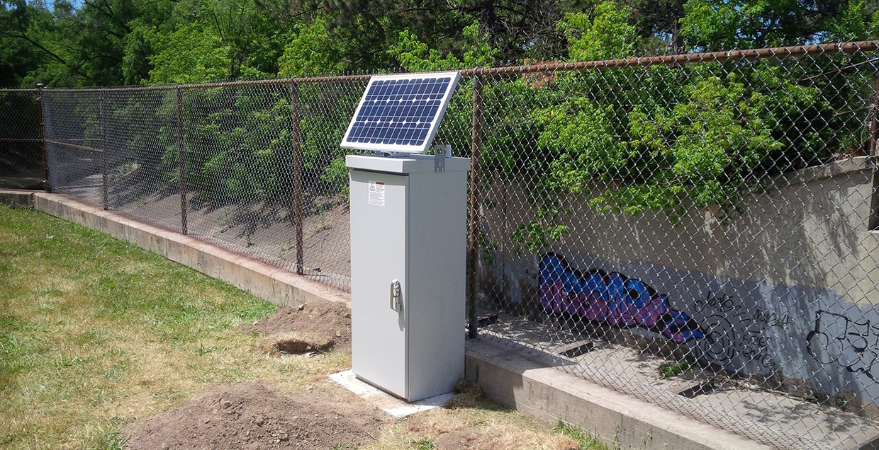

A flood warning gauge was installed in 2015 at Black Creek and Alliance Avenue (above left) to provide TRCA’s flood warning staff with real-time water levels. The stream gauge in the area is called Black Creek at Alliance, which has a live-camera view (above right).
There is also a nearby rain gauge called Westmount Park.
GET REAL-TIME GAUGING INFORMATION

2. BE PREPARED
When it comes to flood preparedness, everyone — homeowners, landlords, renters, and condo owners — has a role to play. You can take steps to prepare; just select a category below to find out more.
3. STAY INFORMED
Use the following sources to stay informed during a flood:
| • Check your local weather online, or on radio or television before you leave the house. |
| • Check Environment Canada’s public weather alerts |
| • Sign up to receive TRCA flood messages |
| • Check your local municipal and public transit social media links (below). |
Social Media Alerts and Notices
Additional Resources
| • Emergency Management Ontario |
| • Ontario’s Emergency Management and Civil Protection Act: Disaster Recovery Assistance for Ontarians |
• Public Safety Canada:
|
| • Flood Smart Canada – Created in partnership with the Insurance Bureau of Canada, this resource is designed to help Canadians better prepare for flooding. |
| • Electrical Safety Authority: Flood Safety Information |
| • Intact Centre on Climate Adaptation: Flood Protection Resources |
| • Institute for Catastrophic Loss Reduction: Protect Your Home from Basement Flooding |
| • City of Toronto: Basement Flooding Study Areas |
Information About Flood Insurance